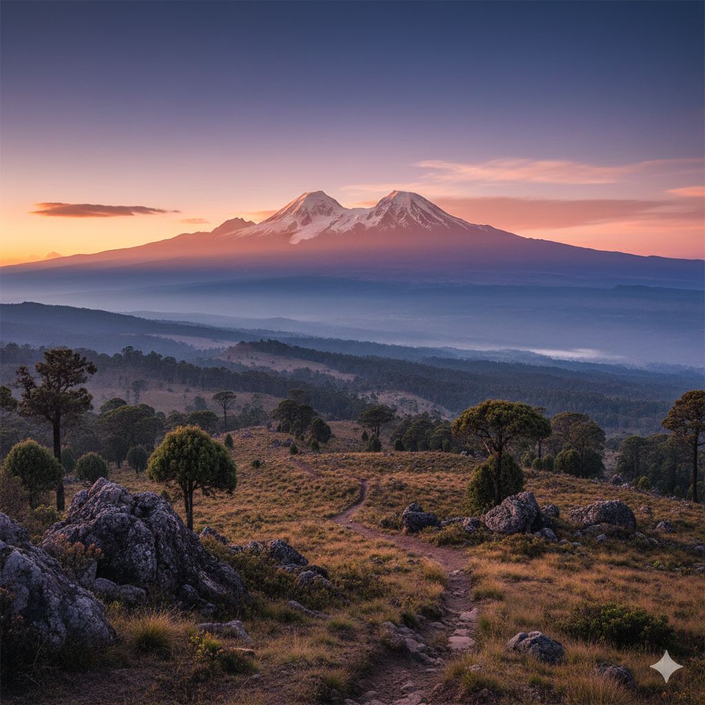
Stand in Nairobi on a clear morning and look north. That distinctive twin-peaked silhouette piercing the horizon 150 kilometers away is Mount Kenya—Kirinyaga to the Kikuyu people, “the mountain of whiteness,” and at 5,199 meters, Africa’s second-highest summit. But this isn’t just another mountain. This is a 3-million-year-old extinct stratovolcano crowned with remnant glaciers, draped in prehistoric-looking vegetation, and recognized by UNESCO in 1997 as a World Heritage Site for reasons that become viscerally clear the moment you set foot on its slopes.
What makes Mount Kenya extraordinary isn’t just its height—though Batian peak’s 5,199 meters certainly commands respect—but rather its remarkable ecological completeness. Nowhere else in Africa can you traverse such a dramatic altitudinal gradient in such a short distance: from dense Podocarpus forests where colobus monkeys swing through moss-draped canopies, through bamboo thickets and giant heather moorlands, into an otherworldly afro-alpine zone where giant groundsels and lobelias tower five meters high like something from a Dr. Seuss illustration, and finally to a nival zone of rock, ice, and rarified air where only the hardiest lichens cling to existence.
The mountain serves as a critical water tower for central Kenya, capturing moisture from the equatorial air and channeling it through glacial valleys and moorland sponges to rivers that sustain approximately two million people downstream. Yet this essential ecosystem faces pressure from climate change—satellite data shows the mountain’s glaciers have retreated dramatically since first measured in 1899, a visible testament to our warming planet.
For travelers, Mount Kenya offers something increasingly rare: genuine adventure that tests your limits while immersing you in landscapes of profound beauty and ecological significance. Whether you’re trekking to Point Lenana’s 4,985-meter summit for sunrise views that span half of Kenya, or attempting technical rock routes up Batian’s glaciated faces, you’ll be walking in the footsteps of legendary mountaineers while experiencing ecosystems found nowhere else on Earth.
The Mountain’s True Story
Straddling the equator across four counties (Meru, Embu, Kirinyaga, Nyeri), Mount Kenya is the eroded heart of a volcano that once towered over 6,500 meters. Today, Batian Peak stands at 5,199 meters—Kenya’s highest point. Gazetted as a National Park in 1949 and honored as a UNESCO World Heritage Site in 1997, its protected complex spans 2,119 km². It is Kenya’s most vital water tower: seven major rivers, including the Tana, originate here, sustaining over two million people downstream (Kenya Forest Service, 2021). And yes—ice remains. Ten fragile glaciers persist, totaling less than 0.3 km² of ice, meticulously monitored by UNEP as critical climate indicators (Global Glacier Change Bulletin No. 4, 2022). This isn’t myth. It’s measurable truth.
The Road to the Roof
The journey to Mount Kenya begins in Nairobi, and thankfully, this is one African mountain adventure that doesn’t require days of bush flying and bone-rattling dirt roads to access. The newly upgraded Thika-Nanyuki Highway—a smooth tarmac ribbon designated the A2—carries you 175 kilometers north through increasingly dramatic landscapes. Budget 3 to 3.5 hours for the drive, watching the urban sprawl of Nairobi give way to pineapple plantations around Thika, then rising through coffee country as the mountain’s bulk gradually dominates your windshield.
Nanyuki town, sitting at 2,000 meters on the mountain’s northwestern flank, serves as the primary base for Mount Kenya expeditions. This bustling equatorial town (yes, the Equator line runs right through it, complete with roadside markers) has evolved to serve mountaineers, with outfitters, last-minute gear shops, and surprisingly good restaurants catering to the pre-trek crowd.
Mount Kenya stands tall in timeless beauty, offering dramatic peaks, rich biodiversity, and unforgettable highland adventures.
If you’re short on time or prefer flying, Nanyuki Airstrip receives scheduled and charter flights from Nairobi’s Wilson Airport—a scenic 45-minute hop that offers spectacular aerial perspectives of the mountain on clear days. International travelers arrive through Jomo Kenyatta International Airport in Nairobi, making Mount Kenya accessible within hours of landing in Kenya.
From Nanyuki, the mountain’s primary access gates lie within 15-32 kilometers, depending on your chosen route. The Sirimon Gate to the northwest sits just 15 kilometers away via good murram road—about 30 minutes of driving. The Naro Moru Gate, accessed via the small town of Naro Moru, lies about 25 kilometers and 45 minutes from Nanyuki. The Chogoria Gate on the mountain’s dramatically scenic eastern side requires routing through Chogoria town and then a 32-kilometer approach that absolutely demands a 4WD vehicle, particularly for reaching the upper roadhead at the meteorological station.
Most organized treks include all ground transfers from either Nairobi or Nanyuki, with sturdy 4WD vehicles handling the final approaches to trailheads. The main access roads remain passable year-round, though the Chogoria approach can become challenging during the heavy rains of April-May and November, when even experienced drivers navigate carefully through mud-slicked sections.
One crucial point: while the drive to Mount Kenya is straightforward, the climbing itself requires genuine physical preparation and proper acclimatization. This isn’t a destination you simply drive to and conquer—the mountain demands respect, planning, and typically 4-6 days of your undivided attention.
Timing Your Ascent
Mount Kenya straddles the equator, which means two things: day length remains consistently around 12 hours year-round (no extended summer evenings or winter darkness to worry about), and the mountain experiences two distinct dry seasons rather than the single summer/winter pattern of temperate zones. Understanding this climatic rhythm is essential to planning a successful climb.
January through February represents the mountain’s prime season—the driest, clearest window when success rates soar and visibility stretches to horizons you didn’t know existed. During these months, precipitation drops to minimal levels, the air crystallizes into startling clarity, and weather patterns stabilize into predictability that’s rare for equatorial mountains. Stand on Point Lenana at dawn during this season and you might see Kilimanjaro’s dome 200 kilometers to the south, with the Indian Ocean visible on exceptionally clear days. The tradeoff? Nighttime temperatures plummet brutally. At altitude, thermometers regularly hit -10°C to -15°C, and exposed skin freezes in minutes. But for those seeking the mountain at its most magnificent, these cold, clear months deliver.
Come August and September, and the mountain enters its second optimal window. This period offers the goldilocks combination of reliable weather, warmer temperatures than the January-February season, and excellent visibility. The nights remain cold—this is still high-altitude equatorial Africa—but not quite as bone-numbingly frigid. These months constitute peak season, meaning you’ll share trails and huts with more climbers, but also benefit from well-established trail conditions and active mountain support.
Between these seasons lie the rains. The long rains from late March through early June transform the mountain into a sodden, cloud-wrapped challenge. Trails turn to mud rivers, visibility shrinks to the next bend, and the psychological toll of ascending in constant wetness shouldn’t be underestimated. Can you climb during these months? Yes, and you’ll have the mountain largely to yourself. Should you, if you have flexibility? Probably not.
The short rains in November through mid-December present a more nuanced picture. Weather patterns become unpredictable, with morning clarity often giving way to afternoon deluges. Yet gaps between systems can provide perfectly acceptable climbing windows for those watching forecasts carefully and maintaining flexible schedules.
For wildlife enthusiasts approaching Mount Kenya for its forest fauna rather than summit attempts, the dry seasons (January-February and July-September) again prove optimal, when animals concentrate around remaining water sources and move more actively through the forests.
Rock climbers targeting Batian and Nelion’s technical routes prioritize January-February when rock faces freeze overnight, providing more stable conditions for the severe routes up the mountain’s volcanic plugs. Ice conditions, while never extensive given the mountain’s equatorial position, achieve their most climbable state during these coldest months.
Temperature deserves its own mention because the range can shock the unprepared. Lower slopes around Nanyuki enjoy pleasant 10-20°C daytime temperatures year-round. The summit zone, however, swings from perhaps +5°C during sunny midday hours to -10°C or colder at night, with windchill driving the effective temperature far lower. Snow remains possible above 4,200 meters throughout the year—yes, even at the equator—and afternoon whiteouts can develop with startling rapidity.
The bottom line for timing? If you have flexibility, target January-February or August-September. If your schedule locks you into shoulder seasons, proceed with appropriate gear and realistic expectations. And if you’re considering the deep rainy seasons, make sure you’re genuinely comfortable with challenging conditions rather than gambling on being the exception to climatic patterns.
When the Mountain Whispers “Come”
Mount Kenya speaks in seasons. Listen closely:
January–February & July–October: Dry windows with rainfall under 80mm/month at 3,500m (Kenya Meteorological Department 30-year normals). Trails are stable. Glaciers gleam under clear skies. Daytime temps: 8–18°C.
Avoid March–May & November–December: Rain softens trails, clouds veil peaks, and rockfall risk rises (Mount Kenya Trust Safety Bulletin, 2023). This isn’t about “perfect weather.” It’s about respecting the mountain’s rhythm.
Walking Through Seven Worlds
Forget “safari” in the savanna sense. Here, your journey is vertical—and transformative. Ascend through seven scientifically documented ecological zones (Mueller-Dombois & Ellenberg classification):
Montane forest → 2. Bamboo → 3. Heather → 4. Giant heather → 5. Afro-alpine moorland → 6. Alpine desert → 7. Nival zone Above 3,500m, a KWS-certified guide is mandatory—a rule protecting both you and the ecosystem. Porters carry loads within Kenya Porters Association limits (max 20kg). Choose your path:
Chogoria Route: Traverse glacial cirques where Lake Michaelson rests in a 3-km-wide amphitheater (Survey of Kenya coordinates verified).
Sirimon-Naro Moru Traverse: Cross heather valleys where giant lobelias stand sentinel. Point Lenana (4,985m) rewards fit trekkers without technical climbing. Batian and Nelion demand certified alpine skills and KWS-licensed guides. At every turn: maintain 50m from wildlife (KWS Code, 2021). This mountain commands humility.
THE TREKKING EXPERIENCE
Let’s be clear from the start: Mount Kenya is fundamentally a mountaineering destination, not a traditional safari. You won’t be game driving through acacia savannah or sipping sundowners while elephants parade past—though you might encounter elephants in the lower forests, and you’ll certainly share campsites with remarkably bold rock hyrax that have mastered the art of begging.
The mountain experience revolves around trekking to Point Lenana (4,985m), the third-highest peak and the ultimate goal for non-technical climbers, or technical climbing on Batian (5,199m) and Nelion (5,188m), pursuits reserved for experienced alpinists with rock climbing skills graded IV-V.
The Classic Trekking Routes to Point Lenana:
The Sirimon-Chogoria Traverse has earned its reputation as the finest trek on the mountain, and having walked it, I understand why. This 4-6 day journey ascends gradually via the northwestern Sirimon route—gentle gradients perfect for acclimatization—summits Point Lenana at dawn, then descends via the spectacular eastern Chogoria route through landscapes so dramatic they seem deliberately designed for Instagram, though they predate social media by a few million years. You’ll pass through every ecological zone, camp beside glacial tarns reflecting groundsels and stars, and descend through gorges that drop away into seeming infinity.
The Naro Moru Route takes the direct approach—4-5 days straight up and down via the mountain’s western flank. This is the most popular route, though not because it’s the prettiest (it’s not) but because it’s the most established. The infamous “vertical bog” section tests patience and waterproofing as you literally squelch upward through a zone that seems to consist entirely of mud, tussocks, and questionable footing. But the route’s directness appeals to time-pressed climbers, and its infrastructure (huts, clear trails) provides reassurance for first-time high-altitude trekkers.
Approach via the Chogoria Route and you’ll understand why photographers obsess over this mountain. This 5-6 day route from the east may be the longest and require the most complicated access, but the payoff comes in spades: the Nithi gorge with its cascading waterfalls, Lake Michaelson cradled at 3,940 meters beneath vertical cliffs, the Temple and Hobley valleys dropping away like the earth simply gave up and fell into itself. If you have time for only one Mount Kenya trek in your lifetime, the scenic argument favors Chogoria.
The Sirimon Route as an up-and-down option (4-5 days) offers the gentlest gradients and arguably the best acclimatization profile, with camps spaced ideally for altitude adjustment. The northwestern approach unfolds through beautiful high moorland, though it lacks the dramatic gorges and tarns that make Chogoria so photogenic.
A Typical Trekking Day:
Dawn breaks around 6:30 AM year-round at the equator, and most trekking days begin shortly after, with porters breaking camp while you nurse a hot drink and contemplate the day’s vertical gain. By 7:00-7:30 AM, you’re walking, climbing steadily through whatever ecological zone currently surrounds you. Expect 4-7 hours of hiking depending on the day’s stage and the route’s acclimatization profile—longer on summit day, shorter on descent stages.
The rhythm settles into something meditative: steady upward progress, frequent breaks as altitude increases, and increasingly surreal vegetation. Arrive at the next camp or mountain hut by early afternoon, giving your body crucial time to adapt to the altitude before nightfall. Experienced guides enforce the alpine truism: “climb high, sleep low,” sometimes building in acclimatization hikes to higher points before returning to camp for the night.
Summit day breaks this pattern entirely. Wakeup calls come brutally early—2:00-3:00 AM—followed by hot tea, nervous energy, and headlamps piercing the darkness as you begin the final push to Point Lenana. The goal? Reaching the 4,985-meter summit for sunrise, when horizontal light ignites Batian and Nelion’s glaciated faces just meters away and the curvature of the earth becomes almost perceptible in the 360-degree horizon. After summit photos and the profound satisfaction of standing at the highest point accessible without technical gear in Kenya, you descend—often all the way to a much lower camp, making summit day the longest and most demanding.
Accommodation on the Mountain:
The mountain’s hut system provides basic but welcome shelter at strategic points. Old Moses Camp, Shipton’s Camp, Klarwill’s Hut, and others offer bunk-style accommodation with mattresses (bring your own sleeping bag rated to at least -10°C), shared pit latrines, and sometimes solar lighting. These are mountain huts in the alpine tradition—shelter and horizontal surfaces, period. No electricity (except limited solar), no running water (collect and purify from streams), no food service, no heat. But after a day at altitude, four walls and a roof feel like luxury. Bookings are required and fees apply.
Camping at designated sites along all routes represents the alternative, requiring full camping equipment from tents to sleeping mats to cooking gear. Most organized treks provide all camping equipment, with porters carrying and setting up camps before clients arrive. There’s something particularly satisfying about camping at 4,200 meters surrounded by groundsels, watching stars emerge in the thinning atmosphere with a clarity lowlanders never experience.
Porters and Guides:
While independent trekking is technically possible with appropriate permits, hiring guides and porters isn’t just recommended—it’s practically essential and economically important to local communities. Guides bring intimate knowledge of weather patterns, route conditions, altitude sickness symptoms, and those countless small decisions that mean the difference between suffering and success at altitude. Porters carry up to 18 kilograms of gear, making your trek infinitely more enjoyable and sustainable.
Standard ratios run about 1 guide per 6-10 trekkers on non-technical routes, with porter numbers scaled to group size and service level. Technical climbs of Batian and Nelion require certified mountain guides at roughly 1:2-4 ratios, and these specialists are mandatory—the climbing is serious, the consequences of errors severe.
Technical Climbing:
If you’re eyeing Batian’s 5,199-meter summit or Nelion at 5,188 meters, understand these are genuine mountaineering objectives requiring rock climbing proficiency (Grade IV-V), comfort with exposure, and experience on alpine terrain. Routes like the Normal Route via the Southeast Face or the North Face Standard Route involve technical pitches, glacier approaches, and all the complexity of high-altitude alpinism. These expeditions typically run 5-7 days, use the same approach routes as Point Lenana treks, then diverge for technical sections requiring ropes, harnesses, helmets, and expertise. Success rates hover around 60-70%, limited by weather, ice conditions, and the simple fact that this is difficult climbing at nearly 5,200 meters.
WILDLIFE AND THE LIVING LANDSCAPE
Come to Mount Kenya expecting Serengeti-style game viewing and you’ll be disappointed. Come expecting something entirely different—a vertical journey through ecosystems stacked atop each other like layers of a particularly elaborate cake, each supporting its own specialized inhabitants—and you’ll be astounded.
The Mountain’s Wild Residents:
Rock hyrax (Procavia capensis) are the mountain’s most ubiquitous characters, and you’ll encounter them constantly up to about 4,200 meters. These guinea pig-sized mammals are, improbably, the closest living relatives to elephants—a fact their appearance thoroughly contradicts. They sun themselves on rocks near huts and camps, emit piercing alarm calls when disturbed, and have absolutely no shame about investigating unattended food. Sighting probability: 99%.
The black-and-white colobus monkey (Colobus guereza) reigns in the forest zones between 2,000-3,000 meters, their spectacular flowing white capes making them unmistakable as they leap between canopies in troops of 10-20 individuals. Their deep, roaring calls echo through the montane forest in the early morning—haunting and wonderful. Sykes’ monkeys (Cercopithecus mitis) share this zone and occasionally become bold around camps, investigating possibilities for food theft with intelligent, appraising eyes.
Various duiker species—Harvey’s red duiker (Cephalophus harveyi) and common duiker among them—inhabit the forest to moorland transition, though these shy antelopes typically dash into cover before you’ve properly registered their presence. Their small size and cryptic behavior make them incidental sightings rather than reliable encounters.
The lower forest slopes harbor larger, more elusive species. African elephants (Loxodonta africana) maintain a small forest population, and while guides can point to fresh dung, stripped bark, and occasionally massive footprints, actual sightings require considerable luck. African buffalo (Syncerus caffer) roam the forest and lower moorland, and these encounters, while rare, inspire respect—forest buffalo are notoriously irritable. Giant forest hogs (Hylochoerus meinertzhageni), the world’s largest wild pigs, root through forest undergrowth, leaving behind churned earth as evidence of their passage.
Leopards (Panthera pardus) absolutely inhabit the mountain, as confirmed by camera trap studies, but seeing one would be extraordinarily fortunate—they’re ghosts even here. The bongo antelope (Tragelaphus eurycerus), a critically endangered forest antelope of stunning beauty with chestnut coats and white stripes, survives in Mount Kenya’s forests, but sightings fall into the “extraordinarily rare” category. Consider it a once-in-a-lifetime encounter if you’re blessed with a glimpse.
For wildlife enthusiasts, the mountain harbors remarkable endemic species that exist nowhere else on Earth: the Mount Kenya mouse shrew (Surdisorex polulus) and Mount Kenya mole rat (Tachyoryctes audax) are locally evolved specialists, though their secretive habits make encounters unlikely without targeted research efforts.
The Birds of Altitude:
Over 130 bird species have been recorded on Mount Kenya, and for birders, the afro-alpine specialists provide the thrill. The scarlet-tufted malachite sunbird (Nectarinia johnstoni) ranges extraordinarily high—up to 4,500 meters—its iridescent green plumage and scarlet feather tufts seeming impossibly vibrant against the harsh alpine environment. Watch for them hovering at lobelia flowers, extracting nectar with specialized bills.
The alpine chat (Pinarochroa sordida) inhabits rocky areas at altitude, a small, brownish bird perfectly adapted to the cold. Augur buzzards (Buteo augur) soar on thermals, and the impressive Mackinder’s eagle-owl (Bubo capensis mackinderi) hunts the moorlands at dusk. Jackson’s francolin scurries through groundsels, while the Abyssinian nightjar emerges at twilight.
Setting realistic expectations: rock hyrax and various bird species represent highly likely encounters. Colobus monkeys are probable in forest zones. Larger mammals like elephants and buffalo are possible but not guaranteed, and genuinely rare species like bongo require extraordinary luck. This isn’t a traditional game-viewing destination—wildlife encounters serve as wonderful bonuses to the primary experience of the mountain itself.
The Layered Landscape:
Mount Kenya’s true spectacle lies in its vegetation zones, each radically different from the last, stacked vertically from 1,600 meters to 5,199 meters—a 3,599-meter gradient that compresses ecological diversity few places can match.
Lower Montane Forest (2,000-2,500m): Your trek typically begins here, in dense forests of Podocarpus and Juniperus (African pencil cedar) draped in epiphytic mosses and lichens that transform every branch into a hanging garden. The air feels thick, humid, primordial. Bamboo zones mark the upper limits, the stems creaking and rustling in wind like a natural percussion section.
Montane Heath and Moorland (2,500-3,500m): Breaking out of the forest feels like emerging onto another planet. Giant heathers—Erica arborea and Philippia species—form twisted forests 3-6 meters tall, their trunks gnarled and contorted by wind and time. Tussock grasses carpet the ground, and the openness after forest confinement feels liberating. This is transition country, preparing you for what lies ahead.
Afro-Alpine Zone (3,500-4,500m): And then you enter the groundsel zone, and suddenly you understand why mountaineers become obsessed with this mountain. Giant groundsels (Dendrosenecio species) tower up to 5 meters, their thick trunks topped with rosettes of leaves that close at night to protect the growing bud from freezing. They look like something Dr. Seuss illustrated after drinking too much coffee—alien, impossible, yet absolutely real.
Giant lobelias (Lobelia telekii and L. keniensis) punctuate the landscape, their tall flowering spikes erupting from ground-level rosettes. At night, water within the rosette freezes, and by day it thaws—yet the plant survives through remarkable adaptations. Helichrysum everlasting flowers add yellows and whites to the palette. The entire zone feels prehistoric, like you’ve walked back 100 million years to an age when plants experimented with forms they’ve since abandoned everywhere else.
Walking through this landscape as sunrise light ignites the dew frozen on every surface—that’s when Mount Kenya transcends mere trekking and becomes something approaching spiritual experience.
Nival Zone (Above 4,500m): Vegetation surrenders to rock and ice. A few hardy lichens and mosses cling to sheltered spots, but essentially, you’ve climbed beyond the living world into the realm of geology and glaciology.
The Geography of Ice and Stone:
Mount Kenya’s topography bears the unmistakable signatures of its volcanic origins and subsequent glaciation. U-shaped valleys carved by Pleistocene ice flows guide your routes upward. Glacial tarns—Lake Michaelson, Lake Ellis, Höhnel Tarn, among others—pool in depressions scooped by ancient ice, their still surfaces reflecting groundsels and sky with mirror clarity.
Twelve remnant glaciers still cling to the highest peaks—Lewis Glacier (the largest), Gregory, Darwin, Tyndall, and others—though satellite monitoring confirms dramatic retreat since first measured in 1899. Climate scientists use Mount Kenya’s glaciers as sensitive indicators of global warming, and the evidence is sobering: these ice bodies are disappearing.
The mountain’s rock displays its volcanic heritage: columnar basalt formations, trachyte plugs forming the twin summits of Batian and Nelion, and extensive scree slopes that make the final approaches to summits exhausting slogs where two steps forward sometimes yield one step back.
Elevation here changes everything. Start at the forest boundary around 1,600 meters where oxygen feels abundant and temperatures moderate, and climb to Batian’s 5,199-meter summit where atmospheric pressure has dropped to roughly 50% of sea level and cold can kill in hours. That 3,599-meter vertical gradient contains multiple worlds, each with its own rules, residents, and remarkable beauty.
MOMENTS THAT MATTER: POINTS OF INTEREST
Certain places on the mountain etch themselves into memory with particular intensity. These are the moments, sites, and experiences that transform Mount Kenya from “another mountain I climbed” into “that mountain I’ll never forget.”
Point Lenana Summit (4,985m) represents the culmination of most treks—the highest point accessible without technical climbing and the third-highest peak on the massif. You’ll arrive in darkness after a 2-3 AM start, frozen and exhausted, questioning your life choices. Then the sun breaks the eastern horizon, horizontal light suddenly ignites Batian and Nelion’s glaciated faces merely 200 meters away yet 200 meters higher, and the entire 360-degree horizon of central Kenya spreads beneath you. Kilimanjaro sometimes reveals itself to the south—a distant volcanic cousin 200 kilometers away. On exceptionally clear days, climbers report seeing the Indian Ocean. The world feels simultaneously immense and intimate from this height, and that sunrise—you’ll chase that feeling for years.
Batian Peak (5,199m), Kenya’s true summit and Africa’s second-highest point, remains the preserve of technical climbers. The rock routes require Grade IV-V climbing skills, comfort with severe exposure, and the ability to function efficiently while hypoxic at nearly 5,200 meters. Standing on Batian’s tiny summit—there’s barely room for two people—delivers one of mountaineering’s great achievements. The feeling of topping out in East Africa, of completing routes pioneered by legends like Shipton and Tilman, of succeeding on terrain that turns back the majority of attempts—that sense of earned accomplishment is precisely why alpinists endure the cold, the altitude, the suffering.
Lake Michaelson at 3,940 meters on the Chogoria route might be the mountain’s most photogenic spot. This glacial tarn nestles beneath vertical cliffs, surrounded by groundsels that reflect perfectly in its still surface when wind drops. Camp here for acclimatization before pushing higher, and you’ll experience African alpine wilderness at its most spectacular. The evening light on the surrounding peaks, the stars emerging in the thin atmosphere, the absolute silence broken only by wind—it’s a cathedral of stone and water.
The Gorges Valley—particularly the Temple, Hobley, and Hinde valleys—demonstrates the mountain’s capacity for drama. These U-shaped glacial valleys drop away with startling verticality, their cliffs plunging hundreds of meters to boulder-strewn floors. The Temple viewpoint on the Chogoria route offers perspectives into these valleys that seem to defy geometry—your brain struggles to process the scale. Side trails allow closer approaches, though the steep terrain demands care and the altitude makes you breathless after minimal exertion.
Mackinder’s Camp and Shipton’s Camp around 4,200 meters in the Teleki Valley serve as base camps for summit attempts, but they’re destinations in themselves. Here, in the heart of the groundsel zone, surrounded by these impossible plants with Batian and Nelion towering above, the mountain’s grandeur becomes inescapable. Shipton’s Cave—a large boulder overhang providing emergency shelter—holds decades of mountaineering history scratched into its rock.
Nithi Falls on the eastern slopes cascades through a gorge in a series of spectacular drops. Accessible as a day hike from the Chogoria route, these falls demonstrate the mountain’s role as water tower—capturing equatorial moisture and channeling it downward through ancient erosion patterns.
The Giant Groundsel and Lobelia Zones (3,400-4,200m) aren’t a single point but rather an experience all routes share. The first time you walk among these prehistoric-looking plants—their scale, their alien forms, the way sunrise light ignites frost on every surface—it rewires your understanding of what “alpine landscape” can mean. Photographers will burn gigabytes of memory cards here, and still feel they haven’t captured it adequately.
Lewis Glacier, the largest remaining ice body, clings to the peak massif between Point Lenana and the main summits. Visible from Point Lenana and accessible via routes from Austrian Hut, it provides tangible connection to the mountain’s icy past while serving as a sobering reminder of climate change. Glaciologists have documented its dramatic retreat, and within decades, Mount Kenya’s glaciers may exist only in photographs and measurements.
QUESTIONS EVERY CLIMBER ASKS
After guiding countless conversations about Mount Kenya, certain questions emerge repeatedly. These aren’t just curiosities—they’re the practical concerns that separate successful, enjoyable climbs from struggles.
What level of fitness do I actually need?
Be honest with yourself here. Trekking to Point Lenana demands good cardiovascular fitness and the ability to walk 4-7 hours daily for multiple consecutive days on steep, uneven terrain while progressively hypoxic. If you can comfortably hike 6-8 hours with a daypack in hilly terrain, you have the baseline. Prior multi-day trekking experience helps tremendously—knowing how your body responds to consecutive long days proves invaluable—but it’s not absolutely mandatory if you’re genuinely fit.
Technical climbs of Batian and Nelion require rock climbing proficiency in the 5.6-5.9 grade range (American system) plus mountaineering skills including glacier travel, rope management, and altitude-efficient movement. If you’re asking whether you’re capable of these routes, you probably aren’t yet—these climbs demand experience, not just fitness.
Start training 8-12 weeks before your climb. Focus on cardiovascular endurance—running, cycling, stair climbing—and specifically include hill work with a weighted backpack. Your cardiovascular system needs to function efficiently at altitude, and your legs need to handle sustained climbing. Core strength and balance work pays dividends on uneven trails.
How serious is altitude sickness?
Extremely serious, and the primary reason people fail to summit despite adequate fitness. Acute Mountain Sickness (AMS) is not a sign of weakness or poor fitness—it’s a physiological response to reduced oxygen partial pressure, and even elite athletes experience it. Point Lenana at 4,985 meters significantly exceeds the altitude where most people develop some symptoms.
Warning signs include severe headache (mild headache is nearly universal), nausea, vomiting, extreme fatigue, shortness of breath at rest, loss of coordination, and altered mental state. If symptoms worsen despite rest at the same altitude, the only reliable treatment is descent—immediately. Severe AMS can progress to life-threatening High Altitude Pulmonary Edema (HAPE) or High Altitude Cerebral Edema (HACE).
Your best defense is proper acclimatization through route choice. Five-to-six-day itineraries significantly outperform four-day rushes. The altitude axiom “climb high, sleep low” works because adaptation happens during rest at altitude. Some climbers use acetazolamide (Diamox) to aid acclimatization—discuss this with a physician experienced in altitude medicine before your trip, as it has contraindications and side effects.
Accept that you’ll feel some symptoms—mild headache, reduced appetite, slightly labored breathing—these are normal. Monitor yourself honestly, communicate symptoms to your guide, and prioritize successful acclimatization over speed. The mountain will be there tomorrow; push too hard and you’ll be descending instead of summiting.
Do I need malaria prophylaxis?
The Mount Kenya region above 2,000 meters, including Nanyuki, falls into a low malaria risk zone where transmission is rare. However, most travelers transit through Nairobi where malaria risk exists, and many combine Mount Kenya with lowland safaris in endemic areas (Maasai Mara, Amboseli, coastal regions).
The rational approach: consult a travel medicine physician who can assess your complete itinerary and risk tolerance, then make personalized recommendations. If you’re flying directly to Nanyuki, spending a week on the mountain, and flying out, prophylaxis may not be warranted. If you’re spending time in Nairobi and heading to lowland parks afterward, it probably is.
Lower forest slopes below 2,000 meters may have seasonal malaria transmission, but trekkers spend minimal time in these zones and typically pass through during daylight hours when mosquito activity is lower.
What should I pack?
Mount Kenya’s temperature extremes—pleasant 15°C afternoons at 3,000 meters and potentially -15°C nights at 5,000 meters—demand a layering system rather than single “warm jacket” thinking.
Essential gear:
Sleeping bag: Four-season, rated to -10°C minimum (better -15°C for comfort)
Footwear: Waterproof hiking boots, fully broken in (blisters at altitude are misery)
Insulation: Down or synthetic insulated jacket, thermal base layers (top and bottom), fleece mid-layer
Weather protection: Waterproof shell jacket and pants (Gore-Tex or equivalent)
Extremities: Warm hat, sun hat, gloves (light and insulated), quality hiking socks (multiple pairs)
Sun protection: SPF 50+ sunscreen, UV-blocking sunglasses (Category 4 for glaciers), lip balm
Trekking poles: Dramatically reduce knee stress on descents
Headlamp: Essential, with spare batteries (cold kills battery life)
Hydration: 3-liter total capacity (bottles or bladder), plus purification method
Personal first aid: Blister treatment, pain relievers, any prescription medications, altitude medication if using
For technical climbs, add: Mountaineering boots, climbing harness, helmet, ice axe, crampons—though outfitters typically provide technical gear, and porters can carry it to base camp.
Don’t forget: The sun at altitude and the equator is punishing—underestimate sun protection at your peril. I’ve seen more treks impacted by severe sunburn than many other preventable problems.
Most organized treks provide detailed, route-specific packing lists. Follow them. This isn’t the place for minimalist experimentation.
What’s the accommodation situation on the mountain?
Forget hotels. Mount Kenya accommodation means either basic mountain huts or camping—both require significant adjustment from lowland comfort expectations.
Mountain huts (Old Moses, Shipton’s, Klarwill’s, Austrian, others) provide bunk beds with mattresses in dormitory-style rooms. You must bring your sleeping bag. Facilities are shared pit latrines—no running water, no showers, no electricity beyond occasional solar panels providing minimal lighting. Water comes from nearby streams and must be purified. There’s no food service; you bring all provisions. No heat beyond what you generate in your sleeping bag. Booking is required, and fees apply per person per night. These huts serve primarily as shelter from weather—and after a day at altitude, that shelter feels genuinely welcome.
Camping at designated sites requires full camping equipment from tents to sleeping mats to cooking gear. Unless you’re independently organizing everything, your trek operator provides all camping equipment, with porters carrying it, setting up before you arrive, and managing camp. There’s something deeply satisfying about camping at 4,200 meters, surrounded by groundsels, watching stars emerge in the crystal atmosphere—until you need to leave your warm sleeping bag at 2 AM for a bathroom break in -10°C temperatures, which is considerably less satisfying.
Both options are basic by design. This is alpine wilderness, and that’s precisely the point. Adjust your expectations, embrace the simplicity, and you’ll find the experience more genuine for its lack of luxury.
Can I trek independently, or must I hire guides?
Technically, you can trek independently with proper permits from Kenya Wildlife Service—the regulations allow it. Practically, hiring guides and porters isn’t just strongly recommended; it’s borderline essential unless you have significant mountaineering self-sufficiency experience.
Guides bring intimate knowledge of weather patterns, route conditions, water sources, and altitude sickness symptoms. They make countless small decisions—when to start, when to rest, whether to push for the summit or turn back—that collectively determine success or failure. They know the mountain’s moods, its dangers, and its generosities from hundreds of ascents.
Porters transform the trek from a survival march into an experience you can actually enjoy. They carry up to 18 kilograms of gear, set up camps, and allow you to trek with only a daypack—making the altitude challenge manageable. Just as importantly, porter and guide fees support local communities economically connected to the mountain.
For technical climbs on Batian and Nelion, certified mountain guides are mandatory—full stop. The climbing is serious (Grade IV-V), the altitude extreme, and the consequences of errors potentially fatal. These aren’t routes for experimentation.
Most visitors book organized treks that include guides, porters, food, camping equipment or hut reservations, and all logistics. It’s the sensible choice.
What percentage of people actually summit Point Lenana?
Kenya Wildlife Service doesn’t publish official statistics, but anecdotal evidence from operators suggests 85-95% of properly acclimatized trekkers on 5-6 day itineraries successfully reach Point Lenana’s summit. Success rates drop noticeably on compressed 4-day itineraries where acclimatization is rushed.
Primary failure factors include inadequate acclimatization (altitude sickness), poor weather (whiteouts, extreme cold), and occasionally simple exhaustion—the 2-3 AM summit push after days of climbing breaks some people.
Technical summits of Batian and Nelion have significantly lower success rates around 60-70%, limited by weather windows, ice conditions, and the simple difficulty of executing technical climbing efficiently at nearly 5,200 meters where oxygen is roughly 50% of sea level.
The encouraging takeaway: choose appropriate itinerary length, train properly, and you have excellent odds of standing on Point Lenana at sunrise. Just prepare mentally for the possibility that conditions or your body may say “not today”—mountains ultimately decide who summits.
Can children climb Mount Kenya?
Lower slopes and forest zones absolutely accommodate children with hiking experience—day hikes and lower-altitude camping can be wonderful family experiences.
Attempting Point Lenana with children under 16 is generally not recommended due to altitude risks, multi-day physical demands, and the maturity required to communicate symptoms and persevere through difficult moments. Individual children vary enormously in fitness, experience, and altitude tolerance, so there’s no absolute cutoff, but err on the side of caution. Altitude sickness can develop more rapidly in children and communication challenges make assessment difficult.
Technical climbs are strictly adult pursuits requiring years of climbing experience.
Family-friendly alternatives include forest walks from Nanyuki, day hikes to lower-altitude viewpoints, and wildlife-focused experiences on the mountain’s lower flanks. Mount Kenya will still be there when your children are older, stronger, and better able to appreciate its challenges and rewards.
What about mobile service and communication?
Safaricom (Kenya’s largest mobile network) provides coverage in Nanyuki and lower mountain slopes, but signal becomes unreliable above 3,000 meters and generally disappears entirely above 3,500 meters. Don’t plan on posting summit selfies to Instagram in real-time—the mountain is genuinely off-grid.
WiFi doesn’t exist on the mountain. Some mountain huts maintain radio communication for emergencies through Kenya Wildlife Service networks, but this is for genuine emergencies, not checking email.
For technical climbs or risk-averse trekkers, satellite phones provide emergency communication backup. Mountain rescue services exist through KWS and specialized mountain rescue teams, but evacuation at high altitude is complex, weather-dependent, and time-consuming. Comprehensive travel insurance including emergency evacuation coverage is essential.
Before departing, inform someone responsible of your itinerary and expected return. When you’re three days out at 4,500 meters, self-sufficiency and your guide’s experience are your primary safety resources.
What about visas for international visitors?
Kenya requires tourist visas for most international visitors. The eVisa system (apply online at www.evisa.go.ke) streamlines the process—apply at least 7 days before departure, though processing can be faster. Single-entry tourist visas currently cost approximately USD 50 and provide 90-day validity.
If combining Kenya with Uganda and Rwanda, the East African tourist visa (USD 100) covers all three countries for 90 days—excellent value for multi-country itineraries.
Yellow fever vaccination certificates are required if arriving from endemic countries (most of sub-Saharan Africa, parts of South America). If flying directly from Europe or North America, yellow fever vaccination isn’t mandatory, though it’s recommended if you’re traveling elsewhere in Kenya or East Africa where transmission occurs.
Passport validity must extend at least 6 months beyond your entry date—this is strictly enforced.
A TREKKER’S TRUTH ABOUT MOUNT KENYA
The Mountain That Touches The Sky
Stand in Nairobi on a clear morning and look north. That distinctive twin-peaked silhouette piercing the horizon 150 kilometers away is Mount Kenya—Kirinyaga to the Kikuyu people, “the mountain of whiteness,” and at 5,199 meters, Africa’s second-highest summit. But this isn’t just another mountain. This is a 3-million-year-old extinct stratovolcano crowned with remnant glaciers, draped in prehistoric-looking vegetation, and recognized by UNESCO in 1997 as a World Heritage Site for reasons that become viscerally clear the moment you set foot on its slopes.
What makes Mount Kenya extraordinary isn’t just its height—though Batian peak’s 5,199 meters certainly commands respect—but rather its remarkable ecological completeness. Nowhere else in Africa can you traverse such a dramatic altitudinal gradient in such a short distance: from dense Podocarpus forests where colobus monkeys swing through moss-draped canopies, through bamboo thickets and giant heather moorlands, into an otherworldly afro-alpine zone where giant groundsels and lobelias tower five meters high like something from a Dr. Seuss illustration, and finally to a nival zone of rock, ice, and rarified air where only the hardiest lichens cling to existence.
The mountain serves as a critical water tower for central Kenya, capturing moisture from the equatorial air and channeling it through glacial valleys and moorland sponges to rivers that sustain approximately two million people downstream. Yet this essential ecosystem faces pressure from climate change—satellite data shows the mountain’s glaciers have retreated dramatically since first measured in 1899, a visible testament to our warming planet.
For travelers, Mount Kenya offers something increasingly rare: genuine adventure that tests your limits while immersing you in landscapes of profound beauty and ecological significance. Whether you’re trekking to Point Lenana’s 4,985-meter summit for sunrise views that span half of Kenya, or attempting technical rock routes up Batian’s glaciated faces, you’ll be walking in the footsteps of legendary mountaineers while experiencing ecosystems found nowhere else on Earth.
The Mountain’s True Story
Straddling the equator across four counties (Meru, Embu, Kirinyaga, Nyeri), Mount Kenya is the eroded heart of a volcano that once towered over 6,500 meters. Today, Batian Peak stands at 5,199 meters—Kenya’s highest point. Gazetted as a National Park in 1949 and honored as a UNESCO World Heritage Site in 1997, its protected complex spans 2,119 km². It is Kenya’s most vital water tower: seven major rivers, including the Tana, originate here, sustaining over two million people downstream (Kenya Forest Service, 2021). And yes—ice remains. Ten fragile glaciers persist, totaling less than 0.3 km² of ice, meticulously monitored by UNEP as critical climate indicators (Global Glacier Change Bulletin No. 4, 2022). This isn’t myth. It’s measurable truth.
The Road to the Roof
The journey to Mount Kenya begins in Nairobi, and thankfully, this is one African mountain adventure that doesn’t require days of bush flying and bone-rattling dirt roads to access. The newly upgraded Thika-Nanyuki Highway—a smooth tarmac ribbon designated the A2—carries you 175 kilometers north through increasingly dramatic landscapes. Budget 3 to 3.5 hours for the drive, watching the urban sprawl of Nairobi give way to pineapple plantations around Thika, then rising through coffee country as the mountain’s bulk gradually dominates your windshield.
Nanyuki town, sitting at 2,000 meters on the mountain’s northwestern flank, serves as the primary base for Mount Kenya expeditions. This bustling equatorial town (yes, the Equator line runs right through it, complete with roadside markers) has evolved to serve mountaineers, with outfitters, last-minute gear shops, and surprisingly good restaurants catering to the pre-trek crowd.
Mount Kenya stands tall in timeless beauty, offering dramatic peaks, rich biodiversity, and unforgettable highland adventures.
If you’re short on time or prefer flying, Nanyuki Airstrip receives scheduled and charter flights from Nairobi’s Wilson Airport—a scenic 45-minute hop that offers spectacular aerial perspectives of the mountain on clear days. International travelers arrive through Jomo Kenyatta International Airport in Nairobi, making Mount Kenya accessible within hours of landing in Kenya.
From Nanyuki, the mountain’s primary access gates lie within 15-32 kilometers, depending on your chosen route. The Sirimon Gate to the northwest sits just 15 kilometers away via good murram road—about 30 minutes of driving. The Naro Moru Gate, accessed via the small town of Naro Moru, lies about 25 kilometers and 45 minutes from Nanyuki. The Chogoria Gate on the mountain’s dramatically scenic eastern side requires routing through Chogoria town and then a 32-kilometer approach that absolutely demands a 4WD vehicle, particularly for reaching the upper roadhead at the meteorological station.
Most organized treks include all ground transfers from either Nairobi or Nanyuki, with sturdy 4WD vehicles handling the final approaches to trailheads. The main access roads remain passable year-round, though the Chogoria approach can become challenging during the heavy rains of April-May and November, when even experienced drivers navigate carefully through mud-slicked sections.
One crucial point: while the drive to Mount Kenya is straightforward, the climbing itself requires genuine physical preparation and proper acclimatization. This isn’t a destination you simply drive to and conquer—the mountain demands respect, planning, and typically 4-6 days of your undivided attention.
Timing Your Ascent
Mount Kenya straddles the equator, which means two things: day length remains consistently around 12 hours year-round (no extended summer evenings or winter darkness to worry about), and the mountain experiences two distinct dry seasons rather than the single summer/winter pattern of temperate zones. Understanding this climatic rhythm is essential to planning a successful climb.
January through February represents the mountain’s prime season—the driest, clearest window when success rates soar and visibility stretches to horizons you didn’t know existed. During these months, precipitation drops to minimal levels, the air crystallizes into startling clarity, and weather patterns stabilize into predictability that’s rare for equatorial mountains. Stand on Point Lenana at dawn during this season and you might see Kilimanjaro’s dome 200 kilometers to the south, with the Indian Ocean visible on exceptionally clear days. The tradeoff? Nighttime temperatures plummet brutally. At altitude, thermometers regularly hit -10°C to -15°C, and exposed skin freezes in minutes. But for those seeking the mountain at its most magnificent, these cold, clear months deliver.
Come August and September, and the mountain enters its second optimal window. This period offers the goldilocks combination of reliable weather, warmer temperatures than the January-February season, and excellent visibility. The nights remain cold—this is still high-altitude equatorial Africa—but not quite as bone-numbingly frigid. These months constitute peak season, meaning you’ll share trails and huts with more climbers, but also benefit from well-established trail conditions and active mountain support.
Between these seasons lie the rains. The long rains from late March through early June transform the mountain into a sodden, cloud-wrapped challenge. Trails turn to mud rivers, visibility shrinks to the next bend, and the psychological toll of ascending in constant wetness shouldn’t be underestimated. Can you climb during these months? Yes, and you’ll have the mountain largely to yourself. Should you, if you have flexibility? Probably not.
The short rains in November through mid-December present a more nuanced picture. Weather patterns become unpredictable, with morning clarity often giving way to afternoon deluges. Yet gaps between systems can provide perfectly acceptable climbing windows for those watching forecasts carefully and maintaining flexible schedules.
For wildlife enthusiasts approaching Mount Kenya for its forest fauna rather than summit attempts, the dry seasons (January-February and July-September) again prove optimal, when animals concentrate around remaining water sources and move more actively through the forests.
Rock climbers targeting Batian and Nelion’s technical routes prioritize January-February when rock faces freeze overnight, providing more stable conditions for the severe routes up the mountain’s volcanic plugs. Ice conditions, while never extensive given the mountain’s equatorial position, achieve their most climbable state during these coldest months.
Temperature deserves its own mention because the range can shock the unprepared. Lower slopes around Nanyuki enjoy pleasant 10-20°C daytime temperatures year-round. The summit zone, however, swings from perhaps +5°C during sunny midday hours to -10°C or colder at night, with windchill driving the effective temperature far lower. Snow remains possible above 4,200 meters throughout the year—yes, even at the equator—and afternoon whiteouts can develop with startling rapidity.
The bottom line for timing? If you have flexibility, target January-February or August-September. If your schedule locks you into shoulder seasons, proceed with appropriate gear and realistic expectations. And if you’re considering the deep rainy seasons, make sure you’re genuinely comfortable with challenging conditions rather than gambling on being the exception to climatic patterns.
When the Mountain Whispers “Come”
Mount Kenya speaks in seasons. Listen closely:
January–February & July–October: Dry windows with rainfall under 80mm/month at 3,500m (Kenya Meteorological Department 30-year normals). Trails are stable. Glaciers gleam under clear skies. Daytime temps: 8–18°C.
Avoid March–May & November–December: Rain softens trails, clouds veil peaks, and rockfall risk rises (Mount Kenya Trust Safety Bulletin, 2023). This isn’t about “perfect weather.” It’s about respecting the mountain’s rhythm.
Walking Through Seven Worlds
Forget “safari” in the savanna sense. Here, your journey is vertical—and transformative. Ascend through seven scientifically documented ecological zones (Mueller-Dombois & Ellenberg classification):
Montane forest → 2. Bamboo → 3. Heather → 4. Giant heather → 5. Afro-alpine moorland → 6. Alpine desert → 7. Nival zone Above 3,500m, a KWS-certified guide is mandatory—a rule protecting both you and the ecosystem. Porters carry loads within Kenya Porters Association limits (max 20kg). Choose your path:
Chogoria Route: Traverse glacial cirques where Lake Michaelson rests in a 3-km-wide amphitheater (Survey of Kenya coordinates verified).
Sirimon-Naro Moru Traverse: Cross heather valleys where giant lobelias stand sentinel. Point Lenana (4,985m) rewards fit trekkers without technical climbing. Batian and Nelion demand certified alpine skills and KWS-licensed guides. At every turn: maintain 50m from wildlife (KWS Code, 2021). This mountain commands humility.
THE TREKKING EXPERIENCE
Let’s be clear from the start: Mount Kenya is fundamentally a mountaineering destination, not a traditional safari. You won’t be game driving through acacia savannah or sipping sundowners while elephants parade past—though you might encounter elephants in the lower forests, and you’ll certainly share campsites with remarkably bold rock hyrax that have mastered the art of begging.
The mountain experience revolves around trekking to Point Lenana (4,985m), the third-highest peak and the ultimate goal for non-technical climbers, or technical climbing on Batian (5,199m) and Nelion (5,188m), pursuits reserved for experienced alpinists with rock climbing skills graded IV-V.
The Classic Trekking Routes to Point Lenana:
The Sirimon-Chogoria Traverse has earned its reputation as the finest trek on the mountain, and having walked it, I understand why. This 4-6 day journey ascends gradually via the northwestern Sirimon route—gentle gradients perfect for acclimatization—summits Point Lenana at dawn, then descends via the spectacular eastern Chogoria route through landscapes so dramatic they seem deliberately designed for Instagram, though they predate social media by a few million years. You’ll pass through every ecological zone, camp beside glacial tarns reflecting groundsels and stars, and descend through gorges that drop away into seeming infinity.
The Naro Moru Route takes the direct approach—4-5 days straight up and down via the mountain’s western flank. This is the most popular route, though not because it’s the prettiest (it’s not) but because it’s the most established. The infamous “vertical bog” section tests patience and waterproofing as you literally squelch upward through a zone that seems to consist entirely of mud, tussocks, and questionable footing. But the route’s directness appeals to time-pressed climbers, and its infrastructure (huts, clear trails) provides reassurance for first-time high-altitude trekkers.
Approach via the Chogoria Route and you’ll understand why photographers obsess over this mountain. This 5-6 day route from the east may be the longest and require the most complicated access, but the payoff comes in spades: the Nithi gorge with its cascading waterfalls, Lake Michaelson cradled at 3,940 meters beneath vertical cliffs, the Temple and Hobley valleys dropping away like the earth simply gave up and fell into itself. If you have time for only one Mount Kenya trek in your lifetime, the scenic argument favors Chogoria.
The Sirimon Route as an up-and-down option (4-5 days) offers the gentlest gradients and arguably the best acclimatization profile, with camps spaced ideally for altitude adjustment. The northwestern approach unfolds through beautiful high moorland, though it lacks the dramatic gorges and tarns that make Chogoria so photogenic.
A Typical Trekking Day:
Dawn breaks around 6:30 AM year-round at the equator, and most trekking days begin shortly after, with porters breaking camp while you nurse a hot drink and contemplate the day’s vertical gain. By 7:00-7:30 AM, you’re walking, climbing steadily through whatever ecological zone currently surrounds you. Expect 4-7 hours of hiking depending on the day’s stage and the route’s acclimatization profile—longer on summit day, shorter on descent stages.
The rhythm settles into something meditative: steady upward progress, frequent breaks as altitude increases, and increasingly surreal vegetation. Arrive at the next camp or mountain hut by early afternoon, giving your body crucial time to adapt to the altitude before nightfall. Experienced guides enforce the alpine truism: “climb high, sleep low,” sometimes building in acclimatization hikes to higher points before returning to camp for the night.
Summit day breaks this pattern entirely. Wakeup calls come brutally early—2:00-3:00 AM—followed by hot tea, nervous energy, and headlamps piercing the darkness as you begin the final push to Point Lenana. The goal? Reaching the 4,985-meter summit for sunrise, when horizontal light ignites Batian and Nelion’s glaciated faces just meters away and the curvature of the earth becomes almost perceptible in the 360-degree horizon. After summit photos and the profound satisfaction of standing at the highest point accessible without technical gear in Kenya, you descend—often all the way to a much lower camp, making summit day the longest and most demanding.
Accommodation on the Mountain:
The mountain’s hut system provides basic but welcome shelter at strategic points. Old Moses Camp, Shipton’s Camp, Klarwill’s Hut, and others offer bunk-style accommodation with mattresses (bring your own sleeping bag rated to at least -10°C), shared pit latrines, and sometimes solar lighting. These are mountain huts in the alpine tradition—shelter and horizontal surfaces, period. No electricity (except limited solar), no running water (collect and purify from streams), no food service, no heat. But after a day at altitude, four walls and a roof feel like luxury. Bookings are required and fees apply.
Camping at designated sites along all routes represents the alternative, requiring full camping equipment from tents to sleeping mats to cooking gear. Most organized treks provide all camping equipment, with porters carrying and setting up camps before clients arrive. There’s something particularly satisfying about camping at 4,200 meters surrounded by groundsels, watching stars emerge in the thinning atmosphere with a clarity lowlanders never experience.
Porters and Guides:
While independent trekking is technically possible with appropriate permits, hiring guides and porters isn’t just recommended—it’s practically essential and economically important to local communities. Guides bring intimate knowledge of weather patterns, route conditions, altitude sickness symptoms, and those countless small decisions that mean the difference between suffering and success at altitude. Porters carry up to 18 kilograms of gear, making your trek infinitely more enjoyable and sustainable.
Standard ratios run about 1 guide per 6-10 trekkers on non-technical routes, with porter numbers scaled to group size and service level. Technical climbs of Batian and Nelion require certified mountain guides at roughly 1:2-4 ratios, and these specialists are mandatory—the climbing is serious, the consequences of errors severe.
Technical Climbing:
If you’re eyeing Batian’s 5,199-meter summit or Nelion at 5,188 meters, understand these are genuine mountaineering objectives requiring rock climbing proficiency (Grade IV-V), comfort with exposure, and experience on alpine terrain. Routes like the Normal Route via the Southeast Face or the North Face Standard Route involve technical pitches, glacier approaches, and all the complexity of high-altitude alpinism. These expeditions typically run 5-7 days, use the same approach routes as Point Lenana treks, then diverge for technical sections requiring ropes, harnesses, helmets, and expertise. Success rates hover around 60-70%, limited by weather, ice conditions, and the simple fact that this is difficult climbing at nearly 5,200 meters.
WILDLIFE AND THE LIVING LANDSCAPE
Come to Mount Kenya expecting Serengeti-style game viewing and you’ll be disappointed. Come expecting something entirely different—a vertical journey through ecosystems stacked atop each other like layers of a particularly elaborate cake, each supporting its own specialized inhabitants—and you’ll be astounded.
The Mountain’s Wild Residents:
Rock hyrax (Procavia capensis) are the mountain’s most ubiquitous characters, and you’ll encounter them constantly up to about 4,200 meters. These guinea pig-sized mammals are, improbably, the closest living relatives to elephants—a fact their appearance thoroughly contradicts. They sun themselves on rocks near huts and camps, emit piercing alarm calls when disturbed, and have absolutely no shame about investigating unattended food. Sighting probability: 99%.
The black-and-white colobus monkey (Colobus guereza) reigns in the forest zones between 2,000-3,000 meters, their spectacular flowing white capes making them unmistakable as they leap between canopies in troops of 10-20 individuals. Their deep, roaring calls echo through the montane forest in the early morning—haunting and wonderful. Sykes’ monkeys (Cercopithecus mitis) share this zone and occasionally become bold around camps, investigating possibilities for food theft with intelligent, appraising eyes.
Various duiker species—Harvey’s red duiker (Cephalophus harveyi) and common duiker among them—inhabit the forest to moorland transition, though these shy antelopes typically dash into cover before you’ve properly registered their presence. Their small size and cryptic behavior make them incidental sightings rather than reliable encounters.
The lower forest slopes harbor larger, more elusive species. African elephants (Loxodonta africana) maintain a small forest population, and while guides can point to fresh dung, stripped bark, and occasionally massive footprints, actual sightings require considerable luck. African buffalo (Syncerus caffer) roam the forest and lower moorland, and these encounters, while rare, inspire respect—forest buffalo are notoriously irritable. Giant forest hogs (Hylochoerus meinertzhageni), the world’s largest wild pigs, root through forest undergrowth, leaving behind churned earth as evidence of their passage.
Leopards (Panthera pardus) absolutely inhabit the mountain, as confirmed by camera trap studies, but seeing one would be extraordinarily fortunate—they’re ghosts even here. The bongo antelope (Tragelaphus eurycerus), a critically endangered forest antelope of stunning beauty with chestnut coats and white stripes, survives in Mount Kenya’s forests, but sightings fall into the “extraordinarily rare” category. Consider it a once-in-a-lifetime encounter if you’re blessed with a glimpse.
For wildlife enthusiasts, the mountain harbors remarkable endemic species that exist nowhere else on Earth: the Mount Kenya mouse shrew (Surdisorex polulus) and Mount Kenya mole rat (Tachyoryctes audax) are locally evolved specialists, though their secretive habits make encounters unlikely without targeted research efforts.
The Birds of Altitude:
Over 130 bird species have been recorded on Mount Kenya, and for birders, the afro-alpine specialists provide the thrill. The scarlet-tufted malachite sunbird (Nectarinia johnstoni) ranges extraordinarily high—up to 4,500 meters—its iridescent green plumage and scarlet feather tufts seeming impossibly vibrant against the harsh alpine environment. Watch for them hovering at lobelia flowers, extracting nectar with specialized bills.
The alpine chat (Pinarochroa sordida) inhabits rocky areas at altitude, a small, brownish bird perfectly adapted to the cold. Augur buzzards (Buteo augur) soar on thermals, and the impressive Mackinder’s eagle-owl (Bubo capensis mackinderi) hunts the moorlands at dusk. Jackson’s francolin scurries through groundsels, while the Abyssinian nightjar emerges at twilight.
Setting realistic expectations: rock hyrax and various bird species represent highly likely encounters. Colobus monkeys are probable in forest zones. Larger mammals like elephants and buffalo are possible but not guaranteed, and genuinely rare species like bongo require extraordinary luck. This isn’t a traditional game-viewing destination—wildlife encounters serve as wonderful bonuses to the primary experience of the mountain itself.
The Layered Landscape:
Mount Kenya’s true spectacle lies in its vegetation zones, each radically different from the last, stacked vertically from 1,600 meters to 5,199 meters—a 3,599-meter gradient that compresses ecological diversity few places can match.
Lower Montane Forest (2,000-2,500m): Your trek typically begins here, in dense forests of Podocarpus and Juniperus (African pencil cedar) draped in epiphytic mosses and lichens that transform every branch into a hanging garden. The air feels thick, humid, primordial. Bamboo zones mark the upper limits, the stems creaking and rustling in wind like a natural percussion section.
Montane Heath and Moorland (2,500-3,500m): Breaking out of the forest feels like emerging onto another planet. Giant heathers—Erica arborea and Philippia species—form twisted forests 3-6 meters tall, their trunks gnarled and contorted by wind and time. Tussock grasses carpet the ground, and the openness after forest confinement feels liberating. This is transition country, preparing you for what lies ahead.
Afro-Alpine Zone (3,500-4,500m): And then you enter the groundsel zone, and suddenly you understand why mountaineers become obsessed with this mountain. Giant groundsels (Dendrosenecio species) tower up to 5 meters, their thick trunks topped with rosettes of leaves that close at night to protect the growing bud from freezing. They look like something Dr. Seuss illustrated after drinking too much coffee—alien, impossible, yet absolutely real.
Giant lobelias (Lobelia telekii and L. keniensis) punctuate the landscape, their tall flowering spikes erupting from ground-level rosettes. At night, water within the rosette freezes, and by day it thaws—yet the plant survives through remarkable adaptations. Helichrysum everlasting flowers add yellows and whites to the palette. The entire zone feels prehistoric, like you’ve walked back 100 million years to an age when plants experimented with forms they’ve since abandoned everywhere else.
Walking through this landscape as sunrise light ignites the dew frozen on every surface—that’s when Mount Kenya transcends mere trekking and becomes something approaching spiritual experience.
Nival Zone (Above 4,500m): Vegetation surrenders to rock and ice. A few hardy lichens and mosses cling to sheltered spots, but essentially, you’ve climbed beyond the living world into the realm of geology and glaciology.
The Geography of Ice and Stone:
Mount Kenya’s topography bears the unmistakable signatures of its volcanic origins and subsequent glaciation. U-shaped valleys carved by Pleistocene ice flows guide your routes upward. Glacial tarns—Lake Michaelson, Lake Ellis, Höhnel Tarn, among others—pool in depressions scooped by ancient ice, their still surfaces reflecting groundsels and sky with mirror clarity.
Twelve remnant glaciers still cling to the highest peaks—Lewis Glacier (the largest), Gregory, Darwin, Tyndall, and others—though satellite monitoring confirms dramatic retreat since first measured in 1899. Climate scientists use Mount Kenya’s glaciers as sensitive indicators of global warming, and the evidence is sobering: these ice bodies are disappearing.
The mountain’s rock displays its volcanic heritage: columnar basalt formations, trachyte plugs forming the twin summits of Batian and Nelion, and extensive scree slopes that make the final approaches to summits exhausting slogs where two steps forward sometimes yield one step back.
Elevation here changes everything. Start at the forest boundary around 1,600 meters where oxygen feels abundant and temperatures moderate, and climb to Batian’s 5,199-meter summit where atmospheric pressure has dropped to roughly 50% of sea level and cold can kill in hours. That 3,599-meter vertical gradient contains multiple worlds, each with its own rules, residents, and remarkable beauty.
MOMENTS THAT MATTER: POINTS OF INTEREST
Certain places on the mountain etch themselves into memory with particular intensity. These are the moments, sites, and experiences that transform Mount Kenya from “another mountain I climbed” into “that mountain I’ll never forget.”
Point Lenana Summit (4,985m) represents the culmination of most treks—the highest point accessible without technical climbing and the third-highest peak on the massif. You’ll arrive in darkness after a 2-3 AM start, frozen and exhausted, questioning your life choices. Then the sun breaks the eastern horizon, horizontal light suddenly ignites Batian and Nelion’s glaciated faces merely 200 meters away yet 200 meters higher, and the entire 360-degree horizon of central Kenya spreads beneath you. Kilimanjaro sometimes reveals itself to the south—a distant volcanic cousin 200 kilometers away. On exceptionally clear days, climbers report seeing the Indian Ocean. The world feels simultaneously immense and intimate from this height, and that sunrise—you’ll chase that feeling for years.
Batian Peak (5,199m), Kenya’s true summit and Africa’s second-highest point, remains the preserve of technical climbers. The rock routes require Grade IV-V climbing skills, comfort with severe exposure, and the ability to function efficiently while hypoxic at nearly 5,200 meters. Standing on Batian’s tiny summit—there’s barely room for two people—delivers one of mountaineering’s great achievements. The feeling of topping out in East Africa, of completing routes pioneered by legends like Shipton and Tilman, of succeeding on terrain that turns back the majority of attempts—that sense of earned accomplishment is precisely why alpinists endure the cold, the altitude, the suffering.
Lake Michaelson at 3,940 meters on the Chogoria route might be the mountain’s most photogenic spot. This glacial tarn nestles beneath vertical cliffs, surrounded by groundsels that reflect perfectly in its still surface when wind drops. Camp here for acclimatization before pushing higher, and you’ll experience African alpine wilderness at its most spectacular. The evening light on the surrounding peaks, the stars emerging in the thin atmosphere, the absolute silence broken only by wind—it’s a cathedral of stone and water.
The Gorges Valley—particularly the Temple, Hobley, and Hinde valleys—demonstrates the mountain’s capacity for drama. These U-shaped glacial valleys drop away with startling verticality, their cliffs plunging hundreds of meters to boulder-strewn floors. The Temple viewpoint on the Chogoria route offers perspectives into these valleys that seem to defy geometry—your brain struggles to process the scale. Side trails allow closer approaches, though the steep terrain demands care and the altitude makes you breathless after minimal exertion.
Mackinder’s Camp and Shipton’s Camp around 4,200 meters in the Teleki Valley serve as base camps for summit attempts, but they’re destinations in themselves. Here, in the heart of the groundsel zone, surrounded by these impossible plants with Batian and Nelion towering above, the mountain’s grandeur becomes inescapable. Shipton’s Cave—a large boulder overhang providing emergency shelter—holds decades of mountaineering history scratched into its rock.
Nithi Falls on the eastern slopes cascades through a gorge in a series of spectacular drops. Accessible as a day hike from the Chogoria route, these falls demonstrate the mountain’s role as water tower—capturing equatorial moisture and channeling it downward through ancient erosion patterns.
The Giant Groundsel and Lobelia Zones (3,400-4,200m) aren’t a single point but rather an experience all routes share. The first time you walk among these prehistoric-looking plants—their scale, their alien forms, the way sunrise light ignites frost on every surface—it rewires your understanding of what “alpine landscape” can mean. Photographers will burn gigabytes of memory cards here, and still feel they haven’t captured it adequately.
Lewis Glacier, the largest remaining ice body, clings to the peak massif between Point Lenana and the main summits. Visible from Point Lenana and accessible via routes from Austrian Hut, it provides tangible connection to the mountain’s icy past while serving as a sobering reminder of climate change. Glaciologists have documented its dramatic retreat, and within decades, Mount Kenya’s glaciers may exist only in photographs and measurements.
QUESTIONS EVERY CLIMBER ASKS
After guiding countless conversations about Mount Kenya, certain questions emerge repeatedly. These aren’t just curiosities—they’re the practical concerns that separate successful, enjoyable climbs from struggles.
What level of fitness do I actually need?
Be honest with yourself here. Trekking to Point Lenana demands good cardiovascular fitness and the ability to walk 4-7 hours daily for multiple consecutive days on steep, uneven terrain while progressively hypoxic. If you can comfortably hike 6-8 hours with a daypack in hilly terrain, you have the baseline. Prior multi-day trekking experience helps tremendously—knowing how your body responds to consecutive long days proves invaluable—but it’s not absolutely mandatory if you’re genuinely fit.
Technical climbs of Batian and Nelion require rock climbing proficiency in the 5.6-5.9 grade range (American system) plus mountaineering skills including glacier travel, rope management, and altitude-efficient movement. If you’re asking whether you’re capable of these routes, you probably aren’t yet—these climbs demand experience, not just fitness.
Start training 8-12 weeks before your climb. Focus on cardiovascular endurance—running, cycling, stair climbing—and specifically include hill work with a weighted backpack. Your cardiovascular system needs to function efficiently at altitude, and your legs need to handle sustained climbing. Core strength and balance work pays dividends on uneven trails.
How serious is altitude sickness?
Extremely serious, and the primary reason people fail to summit despite adequate fitness. Acute Mountain Sickness (AMS) is not a sign of weakness or poor fitness—it’s a physiological response to reduced oxygen partial pressure, and even elite athletes experience it. Point Lenana at 4,985 meters significantly exceeds the altitude where most people develop some symptoms.
Warning signs include severe headache (mild headache is nearly universal), nausea, vomiting, extreme fatigue, shortness of breath at rest, loss of coordination, and altered mental state. If symptoms worsen despite rest at the same altitude, the only reliable treatment is descent—immediately. Severe AMS can progress to life-threatening High Altitude Pulmonary Edema (HAPE) or High Altitude Cerebral Edema (HACE).
Your best defense is proper acclimatization through route choice. Five-to-six-day itineraries significantly outperform four-day rushes. The altitude axiom “climb high, sleep low” works because adaptation happens during rest at altitude. Some climbers use acetazolamide (Diamox) to aid acclimatization—discuss this with a physician experienced in altitude medicine before your trip, as it has contraindications and side effects.
Accept that you’ll feel some symptoms—mild headache, reduced appetite, slightly labored breathing—these are normal. Monitor yourself honestly, communicate symptoms to your guide, and prioritize successful acclimatization over speed. The mountain will be there tomorrow; push too hard and you’ll be descending instead of summiting.
Do I need malaria prophylaxis?
The Mount Kenya region above 2,000 meters, including Nanyuki, falls into a low malaria risk zone where transmission is rare. However, most travelers transit through Nairobi where malaria risk exists, and many combine Mount Kenya with lowland safaris in endemic areas (Maasai Mara, Amboseli, coastal regions).
The rational approach: consult a travel medicine physician who can assess your complete itinerary and risk tolerance, then make personalized recommendations. If you’re flying directly to Nanyuki, spending a week on the mountain, and flying out, prophylaxis may not be warranted. If you’re spending time in Nairobi and heading to lowland parks afterward, it probably is.
Lower forest slopes below 2,000 meters may have seasonal malaria transmission, but trekkers spend minimal time in these zones and typically pass through during daylight hours when mosquito activity is lower.
What should I pack?
Mount Kenya’s temperature extremes—pleasant 15°C afternoons at 3,000 meters and potentially -15°C nights at 5,000 meters—demand a layering system rather than single “warm jacket” thinking.
Essential gear:
Sleeping bag: Four-season, rated to -10°C minimum (better -15°C for comfort)
Footwear: Waterproof hiking boots, fully broken in (blisters at altitude are misery)
Insulation: Down or synthetic insulated jacket, thermal base layers (top and bottom), fleece mid-layer
Weather protection: Waterproof shell jacket and pants (Gore-Tex or equivalent)
Extremities: Warm hat, sun hat, gloves (light and insulated), quality hiking socks (multiple pairs)
Sun protection: SPF 50+ sunscreen, UV-blocking sunglasses (Category 4 for glaciers), lip balm
Trekking poles: Dramatically reduce knee stress on descents
Headlamp: Essential, with spare batteries (cold kills battery life)
Hydration: 3-liter total capacity (bottles or bladder), plus purification method
Personal first aid: Blister treatment, pain relievers, any prescription medications, altitude medication if using
For technical climbs, add: Mountaineering boots, climbing harness, helmet, ice axe, crampons—though outfitters typically provide technical gear, and porters can carry it to base camp.
Don’t forget: The sun at altitude and the equator is punishing—underestimate sun protection at your peril. I’ve seen more treks impacted by severe sunburn than many other preventable problems.
Most organized treks provide detailed, route-specific packing lists. Follow them. This isn’t the place for minimalist experimentation.
What’s the accommodation situation on the mountain?
Forget hotels. Mount Kenya accommodation means either basic mountain huts or camping—both require significant adjustment from lowland comfort expectations.
Mountain huts (Old Moses, Shipton’s, Klarwill’s, Austrian, others) provide bunk beds with mattresses in dormitory-style rooms. You must bring your sleeping bag. Facilities are shared pit latrines—no running water, no showers, no electricity beyond occasional solar panels providing minimal lighting. Water comes from nearby streams and must be purified. There’s no food service; you bring all provisions. No heat beyond what you generate in your sleeping bag. Booking is required, and fees apply per person per night. These huts serve primarily as shelter from weather—and after a day at altitude, that shelter feels genuinely welcome.
Camping at designated sites requires full camping equipment from tents to sleeping mats to cooking gear. Unless you’re independently organizing everything, your trek operator provides all camping equipment, with porters carrying it, setting up before you arrive, and managing camp. There’s something deeply satisfying about camping at 4,200 meters, surrounded by groundsels, watching stars emerge in the crystal atmosphere—until you need to leave your warm sleeping bag at 2 AM for a bathroom break in -10°C temperatures, which is considerably less satisfying.
Both options are basic by design. This is alpine wilderness, and that’s precisely the point. Adjust your expectations, embrace the simplicity, and you’ll find the experience more genuine for its lack of luxury.
Can I trek independently, or must I hire guides?
Technically, you can trek independently with proper permits from Kenya Wildlife Service—the regulations allow it. Practically, hiring guides and porters isn’t just strongly recommended; it’s borderline essential unless you have significant mountaineering self-sufficiency experience.
Guides bring intimate knowledge of weather patterns, route conditions, water sources, and altitude sickness symptoms. They make countless small decisions—when to start, when to rest, whether to push for the summit or turn back—that collectively determine success or failure. They know the mountain’s moods, its dangers, and its generosities from hundreds of ascents.
Porters transform the trek from a survival march into an experience you can actually enjoy. They carry up to 18 kilograms of gear, set up camps, and allow you to trek with only a daypack—making the altitude challenge manageable. Just as importantly, porter and guide fees support local communities economically connected to the mountain.
For technical climbs on Batian and Nelion, certified mountain guides are mandatory—full stop. The climbing is serious (Grade IV-V), the altitude extreme, and the consequences of errors potentially fatal. These aren’t routes for experimentation.
Most visitors book organized treks that include guides, porters, food, camping equipment or hut reservations, and all logistics. It’s the sensible choice.
What percentage of people actually summit Point Lenana?
Kenya Wildlife Service doesn’t publish official statistics, but anecdotal evidence from operators suggests 85-95% of properly acclimatized trekkers on 5-6 day itineraries successfully reach Point Lenana’s summit. Success rates drop noticeably on compressed 4-day itineraries where acclimatization is rushed.
Primary failure factors include inadequate acclimatization (altitude sickness), poor weather (whiteouts, extreme cold), and occasionally simple exhaustion—the 2-3 AM summit push after days of climbing breaks some people.
Technical summits of Batian and Nelion have significantly lower success rates around 60-70%, limited by weather windows, ice conditions, and the simple difficulty of executing technical climbing efficiently at nearly 5,200 meters where oxygen is roughly 50% of sea level.
The encouraging takeaway: choose appropriate itinerary length, train properly, and you have excellent odds of standing on Point Lenana at sunrise. Just prepare mentally for the possibility that conditions or your body may say “not today”—mountains ultimately decide who summits.
Can children climb Mount Kenya?
Lower slopes and forest zones absolutely accommodate children with hiking experience—day hikes and lower-altitude camping can be wonderful family experiences.
Attempting Point Lenana with children under 16 is generally not recommended due to altitude risks, multi-day physical demands, and the maturity required to communicate symptoms and persevere through difficult moments. Individual children vary enormously in fitness, experience, and altitude tolerance, so there’s no absolute cutoff, but err on the side of caution. Altitude sickness can develop more rapidly in children and communication challenges make assessment difficult.
Technical climbs are strictly adult pursuits requiring years of climbing experience.
Family-friendly alternatives include forest walks from Nanyuki, day hikes to lower-altitude viewpoints, and wildlife-focused experiences on the mountain’s lower flanks. Mount Kenya will still be there when your children are older, stronger, and better able to appreciate its challenges and rewards.
What about mobile service and communication?
Safaricom (Kenya’s largest mobile network) provides coverage in Nanyuki and lower mountain slopes, but signal becomes unreliable above 3,000 meters and generally disappears entirely above 3,500 meters. Don’t plan on posting summit selfies to Instagram in real-time—the mountain is genuinely off-grid.
WiFi doesn’t exist on the mountain. Some mountain huts maintain radio communication for emergencies through Kenya Wildlife Service networks, but this is for genuine emergencies, not checking email.
For technical climbs or risk-averse trekkers, satellite phones provide emergency communication backup. Mountain rescue services exist through KWS and specialized mountain rescue teams, but evacuation at high altitude is complex, weather-dependent, and time-consuming. Comprehensive travel insurance including emergency evacuation coverage is essential.
Before departing, inform someone responsible of your itinerary and expected return. When you’re three days out at 4,500 meters, self-sufficiency and your guide’s experience are your primary safety resources.
What about visas for international visitors?
Kenya requires tourist visas for most international visitors. The eVisa system (apply online at www.evisa.go.ke) streamlines the process—apply at least 7 days before departure, though processing can be faster. Single-entry tourist visas currently cost approximately USD 50 and provide 90-day validity.
If combining Kenya with Uganda and Rwanda, the East African tourist visa (USD 100) covers all three countries for 90 days—excellent value for multi-country itineraries.
Yellow fever vaccination certificates are required if arriving from endemic countries (most of sub-Saharan Africa, parts of South America). If flying directly from Europe or North America, yellow fever vaccination isn’t mandatory, though it’s recommended if you’re traveling elsewhere in Kenya or East Africa where transmission occurs.
Passport validity must extend at least 6 months beyond your entry date—this is strictly enforced.